State of Maryland
Nicknames: The Old Line State, The Free State
Motto(s): Fatti maschii, parole femine (Manly deeds, womanly words)
Date of Statehood: April 28, 1788 (7th state)
State Song: “Maryland, My Maryland” by James Ryder Randall
Maryland Flag History
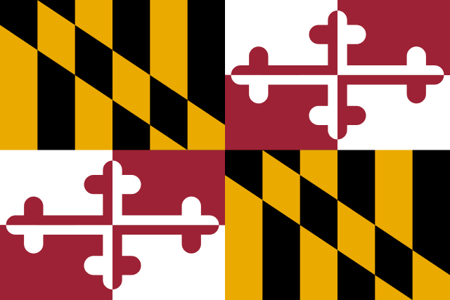
The flag of Maryland, adopted officially in 1904, is a distinctive symbol of the state’s heritage. It features the heraldic banners of the Calvert and Crossland families, the ancestral families of the state’s founder, George Calvert, the first Lord Baltimore. The flag’s design makes it unique among U.S. state flags for its use of British heraldic emblems.
The flag consists of four quadrants. The first and fourth quadrants display the gold and black design of the Calvert family, while the second and third quadrants display the red and white design of the Crossland family. The flag’s design reflects the state’s history as a British colony and its ties to the Calvert family.
The adoption of this flag design followed the period after the Civil War. The inclusion of the Crossland family’s colors, which were used by pro-Confederate Marylanders during the Civil War, along with the Calvert family’s colors, which were associated with Unionist sentiments, symbolized reconciliation and unity after the divisive conflict.
Maryland Quick Facts
Capital City: Annapolis
Abbreviation: MD
Population: Approximately 6 million
Region: South, Mid-Atlantic
Origin of State Name: Named in honor of Henrietta Maria, queen consort of England and wife of King Charles I
Sports Teams: Baltimore Ravens (NFL), Baltimore Orioles (MLB)
Bordering States: Pennsylvania, Delaware, Virginia” data-wpil-keyword-link=”linked”>West Virginia, Virginia
Area Codes: 240, 301, 410, 443, 667
Highest Point: Hoye-Crest at 3,360 feet (1,024 meters)
Lowest Point: Atlantic Ocean
Geography of Maryland
Area: 12,406 square miles (32,133 square kilometers), 42nd largest
Land: 9,707 square miles (25,141 square kilometers), 42nd largest
Water: 2,699 square miles (6,992 square kilometers), 21st largest
Coastline: 31 miles (50 kilometers)
Shoreline: 3,190 miles (5,130 kilometers), including islands and inlets
Largest Cities:
- Baltimore
- Frederick
- Rockville
- Gaithersburg
- Bowie
- Hagerstown
- Annapolis
- College Park
- Salisbury
- Laurel
- Greenbelt
- Cumberland
- Westminster
- Hyattsville
- Takoma Park
National Parks:
- Assateague Island National Seashore
- Chesapeake & Ohio Canal National Historical Park
- Fort McHenry National Monument and Historic Shrine
- Harriet Tubman Underground Railroad National Historical Park
Maryland State Symbols
Living Insignia
State Bird: Baltimore Oriole
State Animal: Thoroughbred horse
State Amphibian: None
State Butterfly: Baltimore Checkerspot butterfly
State Fish: Rockfish (Striped Bass)
State Flower: Black-eyed Susan
State Horse Breed: Thoroughbred
State Insect: Baltimore Checkerspot butterfly
State Mammal: Calico cat (domestic cat)
State Reptile: Diamondback terrapin
Inanimate Insignia
State Fruit: None
State Gemstone: Patuxent River Stone
State Soil: Sassafras soil
State Tree: White Oak
State Quarter: Issued in 2000 featuring the Maryland Statehouse
State Beverage: Milk
State Colors: Red, black, gold, and white (from the state flag)
State Dance: Square Dance
State Food: Blue crab and Smith Island Cake
State Fossil: Ecphora gardnerae gardnerae (shell)
State Mineral: None
State Rock: None